


East Olympia Voting District, Thurston County, Washington
About
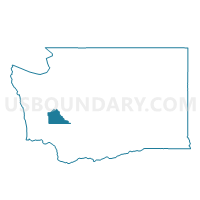
Outline

Summary
| Unique Area Identifier | 689822 |
| Name | East Olympia Voting District |
| County | Thurston County |
| State | Washington |
| Area (square miles) | 3.50 |
| Land Area (square miles) | 3.36 |
| Water Area (square miles) | 0.14 |
| % of Land Area | 96.07 |
| % of Water Area | 3.93 |
| Latitude of the Internal Point | 46.96636000 |
| Longtitude of the Internal Point | -122.85895740 |
Maps


Graphs
Select a template below for downloading or customizing gragh for East Olympia Voting District, Thurston County, Washington


Neighbors
Neighoring Voting District (by Name) Neighboring Voting District on the Map
- Airport Voting District, Thurston County, WA
- Chambers Voting District, Thurston County, WA
- Delridge Voting District, Thurston County, WA
- Hewitt Lake Voting District, Thurston County, WA
- Munn Lake Voting District, Thurston County, WA
- Rich Voting District, Thurston County, WA
- South Union Voting District, Thurston County, WA
- Trails End Voting District, Thurston County, WA
- Tumwater 23 Voting District, Thurston County, WA
- Tumwater 5 Voting District, Thurston County, WA
Top 10 Neighboring County Subdivision (by Population) Neighboring County Subdivision on the Map
- Olympia CCD, Thurston County, WA (161,661)
- Thurston South CCD, Thurston County, WA (39,485)
- Olympia West CCD, Thurston County, WA (18,639)
Top 10 Neighboring Place (by Population) Neighboring Place on the Map
Top 10 Neighboring Unified School District (by Population) Neighboring Unified School District on the Map
Top 10 Neighboring State Legislative District Lower Chamber (by Population) Neighboring State Legislative District Lower Chamber on the Map
Top 10 Neighboring State Legislative District Upper Chamber (by Population) Neighboring State Legislative District Upper Chamber on the Map
Top 10 Neighboring 111th Congressional District (by Population) Neighboring 111th Congressional District on the Map
Top 10 Neighboring Census Tract (by Population) Neighboring Census Tract on the Map
- Census Tract 117.10, Thurston County, WA (7,502)
- Census Tract 108, Thurston County, WA (6,309)
- Census Tract 126.10, Thurston County, WA (5,682)
- Census Tract 117.20, Thurston County, WA (4,540)
- Census Tract 118.21, Thurston County, WA (4,224)